Parc Gwernau, Maesycwmmer
As part of the preparation of Caerphilly County Borough Council’s Replacement Local Development Plan (LDP) an area of land to the south of Maesycwmmer (approximately 212 hectares) has been put forward for the development of a Strategic Site (‘Parc Gwernau’), by a consortium of landowners comprising Barratt David Wilson Homes South Wales and The Trustees of the Llanarth Estates.
Proposed Mix of Uses
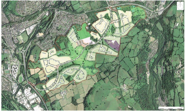
The Parc Gwernau Strategic Site will provide approximately 1,200 new homes over the Replacement LDP period which will run up to 2035 (the site can accommodate approximately 2,700 homes in total with the remaining units to be built within the following LDP period). The site will provide a range and mix of housing sizes, types and tenures suitable for all ages, including affordable units in a wide mix of starter and family homes.
As part of the Strategic Site development, educational facilities will be provided on the site. This will include the provision of land within the site for the construction of a new school. The new school on the Strategic Site would be open for community use, so playing pitches would be included as part of the school which would serve the wider development outside of school hours. In addition, the site will be supported by a range of community services and facilities, including the creation of mixed-use community ‘hubs’ which will comprise employment, small-scale convenience retail, leisure, and recreational facilities. These facilities will be integrated with the surrounding landscape creating a connected series of walkable neighbourhoods within easy reach of open green space and public transport links, with a central spine road linking both ends of the Strategic Site.
Site Assessment Work
A significant amount of survey work has been undertaken on the site in order to confirm that the land is suitable for development, with a specialist consultant team undertaking a detailed analysis of opportunities and constraints within the site and its surroundings. Links to view the following key technical reports can be found below:
- Transport Vision Statement (prepared by Vectos, October 2022)
- Landscape and Visual Appraisal (prepared by the Environmental Dimension Partnership, October 2022)
- Ecology Survey (prepared by Soltys Brewster, August 2021)
- Tree Survey & Arboricultural Report (prepared by ArbTs, October 2022)
- Geoenvironmental and Geotechnical Phase 1 Desk Study Report (prepared by Integral Geotechnique, May 2022 & October 2022)
Framework Masterplan
A Framework Masterplan has been developed for the site, based on the above survey work, which is founded on ‘placemaking’ principles. The Welsh Government defines ‘placemaking’ as follows:
“Placemaking is a holistic approach to the planning and design of development and spaces, focused on positive outcomes. It draws upon an area’s potential to create high quality development and public spaces that promote people’s prosperity, health, happiness, and well-being in the widest sense. Placemaking considers the context, function and relationships between a development site and its wider surroundings” (Planning Policy Wales Edition 11).
With placemaking at the heart of the development proposals, the Framework Masterplan for the Parc Gwernau Strategic Site aims to create:
- A modern community that embraces car-free travel and promotes public transportation, bicycle and pedestrian connections to jobs and local facilities.
- A new sustainable place integrated into the landscape to maximise biodiversity, promote healthy lifestyles and embrace the natural world.
- A place that offers a mix of uses including a new school to improve social cohesion and provide a range of public spaces for interaction, recreation, flexible working, and community events.
A link to the following concept drawings can be found below:
- Framework Masterplan (prepared by EDP)
- Phasing Plan (prepared by EDP)
How Can You Provide Feedback?
Please follow the link below to Caerphilly County Borough Council’s consultation webpage where members of the public have the opportunity to provide any comments on the proposals for the Parc Gwernau Strategic Site. Please note that as this is a statutory consultation exercise being managed by the Council, comments can only be made through the official Council website.
Key Aspects of the Strategic Site
Some of the key aspects of the proposed development at Parc Gwernau are outlined in further detail below, with additional information in the relevant technical reports provided.
Landscape
The Parc Gwernau site is situated immediately adjacent to the settlement boundary of Maesycwmmer and extends southwards to the North Caerphilly ‘Special Landscape Area’ (SLA). Whilst the proposals will have landscape impact, the site nestles behind the adjacent settlement and more visible and sensitive areas will be subject to development of lower densities, with areas of landscape quality retained. The transition from the proposed development areas to the wider countryside will be achieved via a hierarchy of open spaces. These will, in turn, link with existing public footpaths and proposed new links. The site is traversed by a number of Public Rights of Way and several regional long distance recreational routes which will be retained and enhanced as key active travel connections across the site.
Trees, Ecology, and Biodiversity
The site also includes sensitive ecological areas, including a number of designated ‘Sites of Importance for Nature Conservation’ (SINC), which will be retained and enhanced. In addition, the site also contains a number of blocks of Ancient Woodland, many of which are linked to other woodland habitats via connecting hedgerows. The retention, protection and strengthening of the most sensitive areas of the site, including SINC areas, ancient woodland, and hedgerow, is central to the masterplan proposals, so as to improve local biodiversity and maintain the existing landscape character.
Green Infrastructure
Multi-functional and connected Green Infrastructure will link to the wider area and provide opportunities for relaxation, play and recreation alongside ecological provision. The proposals include the integration of watercourses, ponds and other water management measures as appropriate within the public realm and landscape (including in relation to sustainable drainage), and the Green Infrastructure Strategy has ensured a positive response to ecological and landscape sensitivities.
Active Travel
The masterplan incorporates the concept of ‘walkable neighbourhoods’, with a mixture of uses at the centre of the site and at key focal points. The central mixed-use centre will combine small-scale retail and locally accessible services; publicly accessible spaces for interaction and community use; as well as co-worker space to create a vibrant area. The new school will further add to the vibrant mix of uses and provide a community focus. The smaller local hubs will be positioned around green spaces and key routes providing further community facilities. A key feature of Parc Gwernau is combining homes, community uses, businesses and amenities together. Active Travel corridors will provide strong links internally within the site and to the wider local area of Maesycwmmer and transport interchanges. A variety of infrastructure enhancements will prioritise active mobility, in line with Welsh Government’s travel hierarchy, which will prioritise access by walking, cycling and public transport.
Transport and Highway Access
As highlighted within the over-arching ‘Transport Vision’ which has informed the masterplan from the outset, it is anticipated that the step change (which ensures that the masterplan starts with internalising journeys and creating places with locally accessible amenities) will ensure that traffic demand forecasts from the site are minimised. A spine road will link both ends of the Strategic Site - this road will be residential in nature; have a speed limit of 30mph or below; with vertical and horizontal geometry to discourage rat running and excess vehicle speeds. It will provide an alternative route to the current A472, relieving congestion but supported by alternative modes of transport aimed at reducing the number of vehicles travelling between the Crown and Duffryn roundabouts. In this regard, the Transport Vision for the site is focused on a ‘place’-based approach, working towards ‘net zero’ transport by first addressing the role of place in reducing trips, before considering how to increase the proportion of remaining trips that are taken by active, public, and shared forms of transport.
The development will provide numerous mobility initiatives to maximise self-containment and minimise the off-site traffic effect. A multimodal access strategy has been set out, supporting access by sustainable modes and prioritising access by walking, cycling and public transport. A number of inter-linked elements could potentially be explored:
- Masterplanning: a walkable scale of development will enable future residents to undertake a range of day-to-day activities within the development, promoting an active and healthy community through high quality internal routes (both recreational and commuting).
- Flexible Working: the proposals could potentially include an element dedicated to ‘Co Working’ and ‘Close-to-Home’ working space that would allow future residents to be able to work flexibly and reduce their need to travel externally from the site, particularly during peak times.
- Active Travel: a number of Active Travel Corridors could be developed between the site and the existing settlement centres at Maesycwmmer, Ystrad Mynach, Hengoed and Pontllanfraith. These links would provide safe and attractive routes through the site and onwards to these key local destinations as well as the national railway network at Hengoed and Ystrad Mynach.
- Next Generation Mobility Strategy: The development could be supported by a next generation mobility strategy, potentially including elements such as Demand Responsive Transport, mobility hubs and personalised travel planning. The creation of a Mobility Hub on site for example could offer Demand Responsive bus hubs; electric car clubs; EV charging infrastructure; bike share schemes; E-cargo bikes and last mile delivery; scooter hire; a Bike Doctor; and Close to Home work space.
Climate Change
In June 2019 Caerphilly County Borough Council declared a Climate Emergency, committing to making Caerphilly a net zero carbon local authority by 2030 and developing an energy plan for a route towards carbon neutrality. Accordingly, the proposals at Parc Gwernau will ensure that climate change adaptation and resilience measures are incorporated within proposals from the outset. Although only at the early stages of design conception, it is envisaged that the proposed development will support carbon reduction through a variety of measures including the incorporation of sustainable building standards; the use of renewable energy; the provision of broadband connectivity to reduce the need to travel; the development of walkable neighbourhoods; ultra-low emission vehicle charging infrastructure to reduce emissions; quality Green Infrastructure; and the enhancement of biodiversity.
Documents
Arboricultural Report - Summary
Parc Gwernau - Arboricultural Report
Parc Gwernau - Framework Masterplan
Ground Conditions - Summary.docx
Ground Conditions Desk Study Report (May 2022)
Ground Conditions Desk Study Report (October 2022)
Landscape & Visual Appraisal - Summary
Landscape and Visual Appraisal
Vision Statement - Summary.docx
Parc Gwernau - Vision Statement